HarmonyOS 后台位置更新实战:从持续定位到轨迹采集与地理围栏全解析
文章目录

每日一句正能量
“我们之所以犹豫,也许正是因为我们对自己负责。”
通常我们会觉得犹豫是软弱,但犹豫是因为你在乎,你在权衡,你不想敷衍地做决定。这种对自己负责的谨慎,恰恰是一种深层的勇敢。你不是不敢选,而是想选得对得起自己。
摘要
在移动应用开发中,后台位置更新是出行、运动、外勤考勤等场景的核心能力。本文系统讲解 HarmonyOS 提供的后台定位方案,从 LocationKit 持续定位、长时任务保活、轨迹采集优化到地理围栏触发,结合 ArkTS 代码实战,帮助开发者构建稳定可靠的后台位置服务系统。
一、引言:后台位置更新的工程挑战
位置服务是移动应用的高频能力,但后台定位往往比前台定位复杂得多。开发者在实际项目中常遇到以下痛点:
- 退后台即断点:应用切到后台或锁屏后,定位服务被系统挂起,轨迹出现大面积空白或"高空折线"。
- 电量消耗过快:持续高频定位导致设备发热、电量骤降,用户投诉应用"耗电怪兽"。
- 轨迹数据冗余:每秒采集一个定位点,1小时产生3600个点,存储和传输成本高昂。
- 地理围栏失效:应用不在前台时,进出围栏区域无法触发通知,错过关键业务时机。
- 权限管理复杂:前台定位、后台定位、模糊定位、精确定位多种权限交织,申请顺序和时机容易出错。
HarmonyOS 提供了 LocationKit(定位服务)、BackgroundTaskManager(后台任务管理) 和 GeoFence(地理围栏) 三大核心能力。本文将从架构设计到代码实现,系统梳理完整的后台位置更新方案。
二、能力架构:四层定位服务体系
HarmonyOS 的后台位置更新涉及从硬件到应用的完整链路:
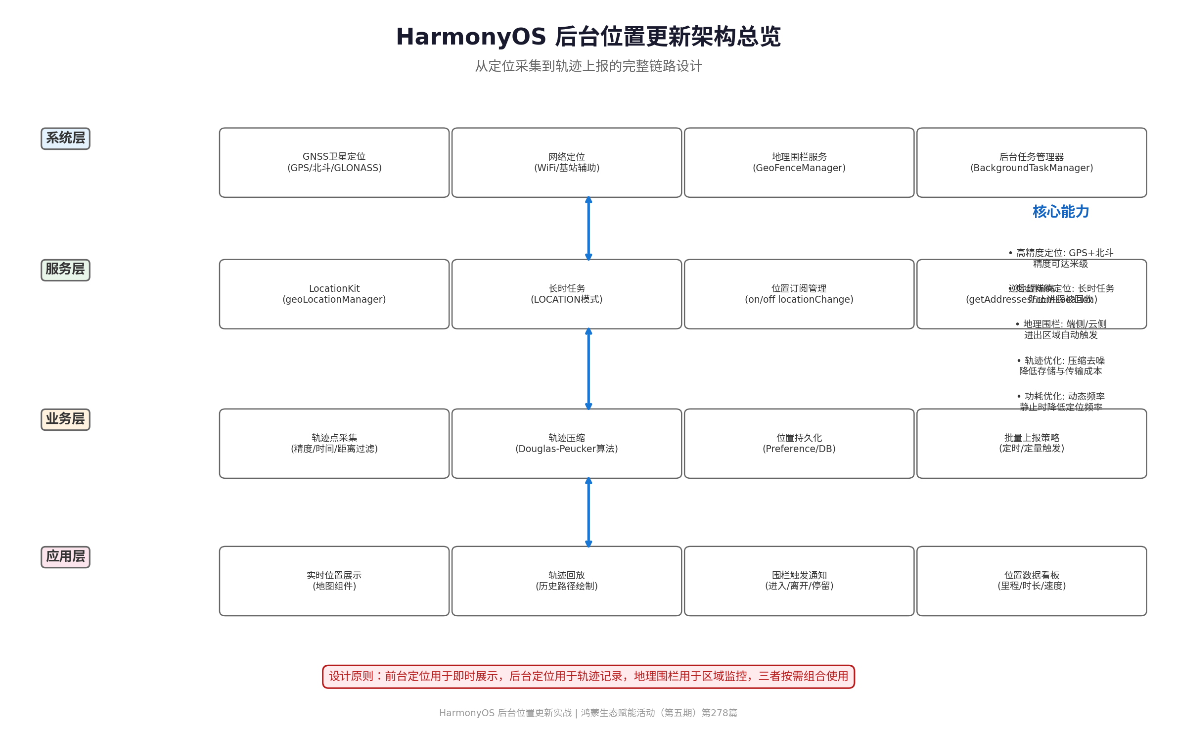
| 层级 | 组件 | 职责 |
|---|---|---|
| 系统层 | GNSS/GPS/北斗、网络定位、地理围栏服务 | 提供底层定位能力和区域监控 |
| 服务层 | LocationKit、长时任务管理、逆地理编码 | 封装系统能力,提供开发者接口 |
| 业务层 | 轨迹采集、轨迹压缩、位置持久化、批量上报 | 处理原始定位数据,转化为业务可用信息 |
| 应用层 | 地图展示、轨迹回放、围栏通知、数据看板 | 面向用户的最终功能呈现 |
核心原则:前台定位用于即时展示(如导航),后台定位用于轨迹记录(如运动),地理围栏用于区域监控(如考勤)。三者按需组合,避免滥用后台定位造成功耗和隐私问题。
三、权限配置与合规准备
后台定位涉及用户敏感数据,权限申请和合规性是前提,缺一不可。
3.1 必备权限清单
| 权限 | 权限名 | 用途 | 申请时机 |
|---|---|---|---|
| 精确位置 | ohos.permission.LOCATION |
获取精准经纬度 | 应用启动时 |
| 模糊位置 | ohos.permission.APPROXIMATELY_LOCATION |
获取模糊位置(兜底) | 应用启动时 |
| 后台位置 | ohos.permission.LOCATION_IN_BACKGROUND |
后台持续获取位置 | 需要后台定位时 |
| 后台运行 | ohos.permission.KEEP_BACKGROUND_RUNNING |
申请长时任务 | 开始轨迹记录时 |
3.2 module.json5 配置
{
  "module": {
    "requestPermissions": [
      {
        "name": "ohos.permission.LOCATION",
        "reason": "$string:location_reason",
        "usedScene": {
          "abilities": ["EntryAbility"],
          "when": "always"
        }
      },
      {
        "name": "ohos.permission.APPROXIMATELY_LOCATION",
        "reason": "$string:location_reason",
        "usedScene": {
          "abilities": ["EntryAbility"],
          "when": "always"
        }
      },
      {
        "name": "ohos.permission.LOCATION_IN_BACKGROUND",
        "reason": "$string:background_location_reason",
        "usedScene": {
          "abilities": ["EntryAbility"],
          "when": "always"
        }
      },
      {
        "name": "ohos.permission.KEEP_BACKGROUND_RUNNING",
        "reason": "$string:background_task_reason",
        "usedScene": {
          "abilities": ["EntryAbility"],
          "when": "always"
        }
      }
    ],
    "abilities": [
      {
        "name": "EntryAbility",
        "backgroundModes": [
          "location"
        ]
      }
    ]
  }
}
关键提示:
backgroundModes: ["location"]必须在abilities中配置,否则即使申请了权限,后台长时任务也无法启动。这是开发者最容易遗漏的配置项。
四、后台长时任务申请与管理
4.1 为什么需要长时任务
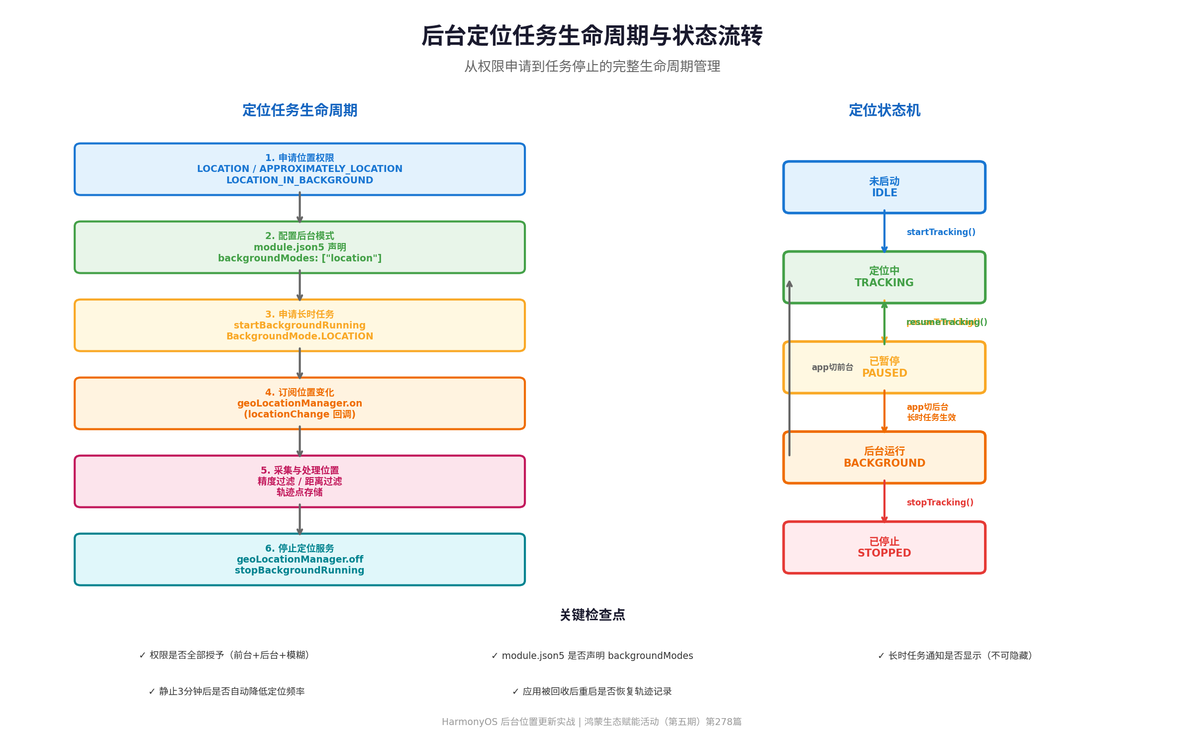
HarmonyOS 为了极致省电和用户隐私,建立了严格的后台冻结机制。任何处于后台的普通应用进程,都会在几分钟内被系统强行转入挂起(Suspended)状态,其各种底层监听和异步回调(包括定位、网络、计时器)都会被全面冷冻。
长时任务(Continuous Task) 是冲破这层防线的唯一合规途径。申请成功后,系统会为应用建立一条持续保活的通道,并强制在状态栏常驻一条通知,让用户明确知晓应用正在后台运行。
4.2 长时任务生命周期管理
长时任务应遵循"用户发起、状态可见、随时可停"的设计原则:
- 用户主动发起:不要在应用启动后无条件开启长时任务。
- 页面明确展示运行状态:让用户知道定位正在进行。
- 通知说明应用正在执行什么:不可隐藏通知。
- 用户停止业务时立即调用停止接口:及时释放系统资源。
- Ability 销毁或业务异常时执行兜底清理:避免资源泄漏。
4.3 代码实战:长时任务管理
// src/manager/LocationBackgroundTaskManager.ets

import { backgroundTaskManager } from '@kit.BackgroundTasksKit';
import { wantAgent } from '@kit.AbilityKit';
import { BusinessError } from '@kit.BasicServicesKit';
import { common } from '@kit.AbilityKit';

/**
 * 定位后台长时任务管理器
 */
export class LocationBackgroundTaskManager {
  private static instance: LocationBackgroundTaskManager | null = null;
  private isRunning: boolean = false;

  public static getInstance(): LocationBackgroundTaskManager {
    if (!LocationBackgroundTaskManager.instance) {
      LocationBackgroundTaskManager.instance = new LocationBackgroundTaskManager();
    }
    return LocationBackgroundTaskManager.instance;
  }

  /**
   * 启动 LOCATION 类型长时任务
   */
  public async startLocationTask(context: common.UIAbilityContext): Promise<void> {
    if (this.isRunning) {
      console.info('[LocationTask] 长时任务已在运行');
      return;
    }

    try {
      // 创建 WantAgent,点击通知时拉起应用
      const wantAgentObj = await wantAgent.getWantAgent(context, {
        wants: [{
          bundleName: context.applicationInfo.bundleName,
          abilityName: context.abilityInfo.name
        }],
        operationType: wantAgent.OperationType.START_ABILITY,
        requestCode: 0,
        wantAgentFlags: [wantAgent.WantAgentFlags.UPDATE_PRESENT_FLAG]
      });

      // 启动长时任务
      await backgroundTaskManager.startBackgroundRunning(
        context,
        backgroundTaskManager.BackgroundMode.LOCATION,
        wantAgentObj
      );

      this.isRunning = true;
      console.info('[LocationTask] LOCATION 长时任务已启动');
    } catch (error) {
      const err = error as BusinessError;
      console.error(`[LocationTask] 启动长时任务失败: ${err.code}, ${err.message}`);
      throw error;
    }
  }

  /**
   * 停止 LOCATION 长时任务
   */
  public async stopLocationTask(context: common.UIAbilityContext): Promise<void> {
    if (!this.isRunning) return;

    try {
      await backgroundTaskManager.stopBackgroundRunning(context);
      this.isRunning = false;
      console.info('[LocationTask] LOCATION 长时任务已停止');
    } catch (error) {
      const err = error as BusinessError;
      console.error(`[LocationTask] 停止长时任务失败: ${err.code}, ${err.message}`);
    }
  }

  public getIsRunning(): boolean {
    return this.isRunning;
  }
}
五、持续定位与位置订阅
5.1 定位参数配置
LocationKit 提供了灵活的定位参数配置,开发者需要根据业务场景平衡精度与功耗:
import { geoLocationManager } from '@kit.LocationKit';

// 高精度定位请求(适合导航、运动轨迹)
const highAccuracyRequest: geoLocationManager.LocationRequest = {
  priority: geoLocationManager.LocationRequestPriority.FIRST_FIX,  // 首次定位优先
  scenario: geoLocationManager.LocationScenario.NAVIGATION,         // 导航场景
  timeInterval: 1000,    // 定位间隔 1 秒
  distanceInterval: 0,   // 每次位置变化都回调
  maxAccuracy: 0         // 不限制精度
};

// 平衡功耗定位请求(适合日常轨迹记录)
const balancedRequest: geoLocationManager.LocationRequest = {
  priority: geoLocationManager.LocationRequestPriority.HIGH_ACCURACY,
  scenario: geoLocationManager.LocationScenario.TRACKING,           // 轨迹跟踪场景
  timeInterval: 5000,    // 定位间隔 5 秒
  distanceInterval: 10,  // 移动超过 10 米才回调
  maxAccuracy: 50        // 最大精度 50 米
};

// 低功耗定位请求(适合城市通勤)
const lowPowerRequest: geoLocationManager.LocationRequest = {
  priority: geoLocationManager.LocationRequestPriority.LOW_POWER,
  scenario: geoLocationManager.LocationScenario.DAILY_LIFE_SERVICE, // 日常服务场景
  timeInterval: 30000,   // 定位间隔 30 秒
  distanceInterval: 50,  // 移动超过 50 米才回调
  maxAccuracy: 100       // 最大精度 100 米
};
5.2 位置订阅与取消
// src/manager/LocationTracker.ets

import { geoLocationManager } from '@kit.LocationKit';
import { BusinessError } from '@kit.BasicServicesKit';

/**
 * 位置追踪器
 * 负责订阅位置变化、采集定位点、管理定位生命周期
 */
export class LocationTracker {
  private static instance: LocationTracker | null = null;
  private isTracking: boolean = false;
  private locationCallback?: (location: geoLocationManager.Location) => void;

  public static getInstance(): LocationTracker {
    if (!LocationTracker.instance) {
      LocationTracker.instance = new LocationTracker();
    }
    return LocationTracker.instance;
  }

  /**
   * 开始持续定位
   */
  public startTracking(
    callback: (location: geoLocationManager.Location) => void,
    request?: geoLocationManager.LocationRequest
  ): void {
    if (this.isTracking) {
      console.info('[LocationTracker] 定位已在进行中');
      return;
    }

    this.locationCallback = callback;

    // 默认使用轨迹跟踪配置
    const locationRequest = request || {
      priority: geoLocationManager.LocationRequestPriority.HIGH_ACCURACY,
      scenario: geoLocationManager.LocationScenario.TRACKING,
      timeInterval: 5000,
      distanceInterval: 10,
      maxAccuracy: 50
    };

    try {
      geoLocationManager.on('locationChange', locationRequest, this.handleLocationChange);
      this.isTracking = true;
      console.info('[LocationTracker] 位置订阅已启动');
    } catch (error) {
      const err = error as BusinessError;
      console.error(`[LocationTracker] 启动定位失败: ${err.code}, ${err.message}`);
    }
  }

  /**
   * 停止持续定位
   */
  public stopTracking(): void {
    if (!this.isTracking) return;

    try {
      geoLocationManager.off('locationChange', this.handleLocationChange);
      this.isTracking = false;
      this.locationCallback = undefined;
      console.info('[LocationTracker] 位置订阅已停止');
    } catch (error) {
      const err = error as BusinessError;
      console.error(`[LocationTracker] 停止定位失败: ${err.code}, ${err.message}`);
    }
  }

  /**
   * 获取单次位置(用于快速获取当前位置)
   */
  public async getCurrentLocation(): Promise<geoLocationManager.Location> {
    return new Promise((resolve, reject) => {
      try {
        geoLocationManager.getCurrentLocation(
          { priority: geoLocationManager.LocationRequestPriority.FIRST_FIX },
          (location) => {
            resolve(location);
          }
        );
      } catch (error) {
        reject(error);
      }
    });
  }

  /**
   * 位置变化处理
   */
  private handleLocationChange = (location: geoLocationManager.Location): void => {
    console.info(`[LocationTracker] 位置更新: lat=${location.latitude.toFixed(6)}, ` +
                 `lng=${location.longitude.toFixed(6)}, accuracy=${location.accuracy}m`);
    this.locationCallback?.(location);
  };

  public getIsTracking(): boolean {
    return this.isTracking;
  }
}
5.3 关键注意事项
- 定位参数平衡:
timeInterval和distanceInterval越小,精度越高,但功耗越大。建议根据业务场景动态调整。 - 回调频率控制:系统实际回调频率可能高于设定值,业务层需要做好去重和过滤。
- 静止检测:当设备静止超过 3 分钟时,系统可能降低定位频率甚至暂停回调,需要拿起设备移动后才会恢复。
- 权限动态申请:
LOCATION_IN_BACKGROUND属于敏感权限,需要在运行时动态申请,并引导用户选择"始终允许"。
六、轨迹采集与优化策略
6.1 原始定位点处理
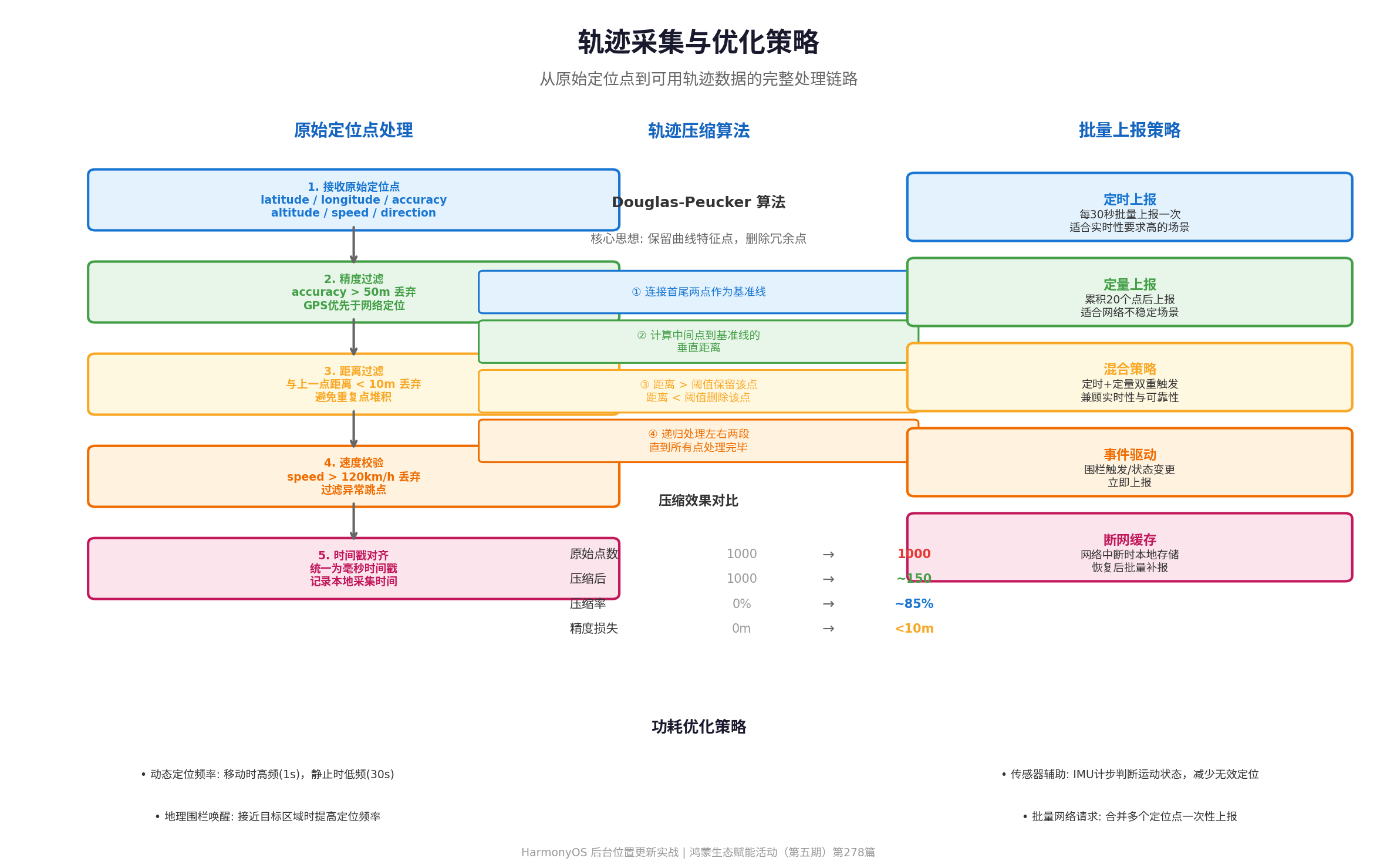
从 LocationKit 获取的原始定位点不能直接作为轨迹数据使用,需要经过多层过滤和校验:
// src/model/TrackTypes.ets

/**
 * 轨迹点模型
 */
export interface TrackPoint {
  latitude: number;
  longitude: number;
  altitude?: number;
  accuracy: number;
  speed?: number;
  direction?: number;
  timestamp: number;      // 采集时间戳(毫秒)
  source: 'gps' | 'network' | 'fused';
}

/**
 * 轨迹段模型
 */
export interface TrackSegment {
  segmentId: string;
  points: TrackPoint[];
  startTime: number;
  endTime: number;
  distance: number;       // 段距离(米)
  duration: number;       // 段时长(毫秒)
}
6.2 轨迹过滤器实现
// src/manager/TrackFilter.ets

import { TrackPoint } from '../model/TrackTypes';

/**
 * 轨迹过滤器
 * 对原始定位点进行精度、距离、速度过滤
 */
export class TrackFilter {
  // 过滤阈值
  private readonly MIN_ACCURACY = 50;      // 精度超过50米丢弃
  private readonly MIN_DISTANCE = 10;      // 与上一点距离小于10米丢弃
  private readonly MAX_SPEED = 120;        // 速度超过120km/h丢弃
  private readonly MAX_SPEED_MS = this.MAX_SPEED * 1000 / 3600;

  private lastValidPoint: TrackPoint | null = null;

  /**
   * 过滤单个定位点
   */
  public filter(point: TrackPoint): TrackPoint | null {
    // 1. 精度过滤
    if (point.accuracy > this.MIN_ACCURACY) {
      console.info(`[TrackFilter] 精度过滤: accuracy=${point.accuracy}m > ${this.MIN_ACCURACY}m`);
      return null;
    }

    // 2. 如果是第一个点,直接通过
    if (!this.lastValidPoint) {
      this.lastValidPoint = point;
      return point;
    }

    // 3. 距离过滤
    const distance = this.calculateDistance(this.lastValidPoint, point);
    if (distance < this.MIN_DISTANCE) {
      console.info(`[TrackFilter] 距离过滤: distance=${distance.toFixed(1)}m < ${this.MIN_DISTANCE}m`);
      return null;
    }

    // 4. 速度校验
    if (point.speed !== undefined && point.speed > this.MAX_SPEED_MS) {
      console.info(`[TrackFilter] 速度过滤: speed=${(point.speed * 3.6).toFixed(1)}km/h > ${this.MAX_SPEED}km/h`);
      return null;
    }

    this.lastValidPoint = point;
    return point;
  }

  /**
   * 重置过滤器
   */
  public reset(): void {
    this.lastValidPoint = null;
  }

  /**
   * 计算两点间距离(Haversine公式)
   */
  private calculateDistance(p1: TrackPoint, p2: TrackPoint): number {
    const R = 6371000; // 地球半径(米)
    const lat1Rad = this.toRadians(p1.latitude);
    const lat2Rad = this.toRadians(p2.latitude);
    const deltaLat = this.toRadians(p2.latitude - p1.latitude);
    const deltaLng = this.toRadians(p2.longitude - p1.longitude);

    const a = Math.sin(deltaLat / 2) * Math.sin(deltaLat / 2) +
              Math.cos(lat1Rad) * Math.cos(lat2Rad) *
              Math.sin(deltaLng / 2) * Math.sin(deltaLng / 2);
    const c = 2 * Math.atan2(Math.sqrt(a), Math.sqrt(1 - a));

    return R * c;
  }

  private toRadians(degrees: number): number {
    return degrees * Math.PI / 180;
  }
}
6.3 轨迹压缩算法(Douglas-Peucker)
轨迹压缩的核心思想是保留曲线的特征点,删除冗余点。Douglas-Peucker 算法是业界最常用的轨迹压缩算法:
// src/manager/TrackCompressor.ets

import { TrackPoint } from '../model/TrackTypes';

/**
 * 轨迹压缩器(Douglas-Peucker算法)
 */
export class TrackCompressor {
  private readonly DEFAULT_THRESHOLD = 10; // 默认阈值10米

  /**
   * 压缩轨迹点数组
   */
  public compress(points: TrackPoint[], threshold?: number): TrackPoint[] {
    if (points.length <= 2) return points;

    const epsilon = threshold || this.DEFAULT_THRESHOLD;
    const result: TrackPoint[] = [];

    // 递归处理
    this.douglasPeucker(points, 0, points.length - 1, epsilon, result);

    // 按原始顺序排序
    result.sort((a, b) => a.timestamp - b.timestamp);

    const compressionRate = ((1 - result.length / points.length) * 100).toFixed(1);
    console.info(`[TrackCompressor] 压缩前: ${points.length}点, 压缩后: ${result.length}点, 压缩率: ${compressionRate}%`);

    return result;
  }

  /**
   * Douglas-Peucker 递归实现
   */
  private douglasPeucker(
    points: TrackPoint[],
    start: number,
    end: number,
    epsilon: number,
    result: TrackPoint[]
  ): void {
    // 保留首尾两点
    if (start === end) {
      if (!result.includes(points[start])) {
        result.push(points[start]);
      }
      return;
    }

    result.push(points[start]);
    result.push(points[end]);

    if (end - start <= 1) return;

    // 找到距离基准线最远的点
    let maxDistance = 0;
    let maxIndex = start;

    for (let i = start + 1; i < end; i++) {
      const distance = this.perpendicularDistance(
        points[i],
        points[start],
        points[end]
      );
      if (distance > maxDistance) {
        maxDistance = distance;
        maxIndex = i;
      }
    }

    // 如果最大距离超过阈值,保留该点并递归处理
    if (maxDistance > epsilon) {
      // 移除之前添加的 end 点(会在递归中重新添加)
      const endIndex = result.indexOf(points[end]);
      if (endIndex > -1) result.splice(endIndex, 1);

      this.douglasPeucker(points, start, maxIndex, epsilon, result);
      this.douglasPeucker(points, maxIndex, end, epsilon, result);
    }
  }

  /**
   * 计算点到线段的垂直距离
   */
  private perpendicularDistance(point: TrackPoint, lineStart: TrackPoint, lineEnd: TrackPoint): number {
    // 使用 Haversine 距离近似计算
    const A = lineEnd.longitude - lineStart.longitude;
    const B = lineStart.latitude - lineEnd.latitude;
    const C = lineEnd.latitude * lineStart.longitude - lineStart.latitude * lineEnd.longitude;

    const numerator = Math.abs(A * point.latitude + B * point.longitude + C);
    const denominator = Math.sqrt(A * A + B * B);

    // 转换为米(近似)
    return (numerator / denominator) * 111000;
  }
}
七、位置上报与持久化
7.1 批量上报策略
后台定位产生的数据需要及时上报到服务端,但频繁的网络请求会消耗大量电量。推荐采用"定时 + 定量"的混合策略:
// src/manager/LocationUploader.ets

import { http } from '@kit.NetworkKit';
import { BusinessError } from '@kit.BasicServicesKit';
import { TrackPoint } from '../model/TrackTypes';

/**
 * 位置数据上传管理器
 * 采用定时+定量混合策略,兼顾实时性与功耗
 */
export class LocationUploader {
  private static instance: LocationUploader | null = null;

  private pendingPoints: TrackPoint[] = [];
  private uploadTimer: number | null = null;

  // 上报配置
  private readonly BATCH_SIZE = 20;        // 每批最多20个点
  private readonly UPLOAD_INTERVAL = 30000; // 每30秒上报一次
  private readonly MAX_RETRY = 3;          // 最大重试次数
  private readonly RETRY_DELAY = 5000;     // 重试间隔5秒

  public static getInstance(): LocationUploader {
    if (!LocationUploader.instance) {
      LocationUploader.instance = new LocationUploader();
    }
    return LocationUploader.instance;
  }

  /**
   * 添加待上报点位
   */
  public addPoint(point: TrackPoint): void {
    this.pendingPoints.push(point);

    // 达到批量阈值立即上报
    if (this.pendingPoints.length >= this.BATCH_SIZE) {
      this.uploadBatch();
    }
  }

  /**
   * 启动定时上报
   */
  public startScheduledUpload(): void {
    if (this.uploadTimer !== null) return;

    this.uploadTimer = setInterval(() => {
      if (this.pendingPoints.length > 0) {
        this.uploadBatch();
      }
    }, this.UPLOAD_INTERVAL);

    console.info('[LocationUploader] 定时上报已启动');
  }

  /**
   * 停止定时上报
   */
  public stopScheduledUpload(): void {
    if (this.uploadTimer !== null) {
      clearInterval(this.uploadTimer);
      this.uploadTimer = null;
      console.info('[LocationUploader] 定时上报已停止');
    }

    // 上报剩余数据
    if (this.pendingPoints.length > 0) {
      this.uploadBatch();
    }
  }

  /**
   * 批量上报
   */
  private async uploadBatch(retryCount: number = 0): Promise<void> {
    if (this.pendingPoints.length === 0) return;

    const batch = this.pendingPoints.splice(0, this.BATCH_SIZE);
    const payload = {
      deviceId: 'device_id_placeholder',
      batchId: `batch_${Date.now()}`,
      points: batch.map(p => ({
        lat: p.latitude,
        lng: p.longitude,
        accuracy: p.accuracy,
        speed: p.speed,
        timestamp: p.timestamp
      })),
      count: batch.length
    };

    try {
      const httpRequest = http.createHttp();
      const response = await httpRequest.request(
        'https://your-server.com/api/location/batch',
        {
          method: http.RequestMethod.POST,
          header: {
            'Content-Type': 'application/json',
            'Authorization': 'Bearer your-token'
          },
          extraData: JSON.stringify(payload)
        }
      );
      httpRequest.destroy();

      if (response.responseCode === 200) {
        console.info(`[LocationUploader] 批量上报成功: ${batch.length}点`);
      } else {
        throw new Error(`服务器返回: ${response.responseCode}`);
      }
    } catch (error) {
      console.error(`[LocationUploader] 上报失败: ${(error as BusinessError).message}`);

      // 重试机制
      if (retryCount < this.MAX_RETRY) {
        console.info(`[LocationUploader] ${this.RETRY_DELAY}ms后第${retryCount + 1}次重试`);
        setTimeout(() => {
          // 将失败数据放回队列头部
          this.pendingPoints.unshift(...batch);
          this.uploadBatch(retryCount + 1);
        }, this.RETRY_DELAY * (retryCount + 1));
      } else {
        console.error('[LocationUploader] 超过最大重试次数,数据已丢失');
      }
    }
  }
}
八、地理围栏(GeoFence)
8.1 地理围栏原理
地理围栏是一种基于位置的虚拟边界技术,当设备进入、离开或在围栏区域内停留一定时间时,系统会自动触发回调。HarmonyOS 支持端侧 GNSS 围栏和云侧围栏两种方案。
8.2 端侧 GNSS 围栏实现
// src/manager/GeoFenceManager.ets

import { geoLocationManager } from '@kit.LocationKit';
import { wantAgent } from '@kit.AbilityKit';
import { BusinessError } from '@kit.BasicServicesKit';
import { common } from '@kit.AbilityKit';

/**
 * 地理围栏管理器
 */
export class GeoFenceManager {
  private static instance: GeoFenceManager | null = null;
  private context: common.UIAbilityContext | null = null;

  public static getInstance(): GeoFenceManager {
    if (!GeoFenceManager.instance) {
      GeoFenceManager.instance = new GeoFenceManager();
    }
    return GeoFenceManager.instance;
  }

  public setContext(context: common.UIAbilityContext): void {
    this.context = context;
  }

  /**
   * 注册圆形地理围栏
   */
  public async registerCircularFence(
    latitude: number,
    longitude: number,
    radius: number,      // 半径(米)
    expiration: number    // 有效期(毫秒)
  ): Promise<void> {
    if (!this.context) {
      throw new Error('Context 未设置');
    }

    try {
      // 创建 WantAgent,围栏触发时拉起应用
      const wantAgentObj = await wantAgent.getWantAgent(this.context, {
        wants: [{
          bundleName: this.context.applicationInfo.bundleName,
          abilityName: this.context.abilityInfo.name,
          parameters: { fenceTrigger: true }
        }],
        operationType: wantAgent.OperationType.START_ABILITY,
        requestCode: 0,
        wantAgentFlags: [wantAgent.WantAgentFlags.UPDATE_PRESENT_FLAG]
      });

      // 配置围栏请求
      const geofenceRequest: geoLocationManager.GeofenceRequest = {
        scenario: 0x301, // 日常位置监控场景
        geofence: {
          latitude,
          longitude,
          radius,
          expiration
        }
      };

      // 注册围栏监听
      geoLocationManager.on('gnssFenceStatusChange', geofenceRequest, wantAgentObj);
      console.info(`[GeoFence] 围栏注册成功: 中心(${latitude}, ${longitude}), 半径${radius}m`);
    } catch (error) {
      const err = error as BusinessError;
      console.error(`[GeoFence] 围栏注册失败: ${err.code}, ${err.message}`);
      throw error;
    }
  }

  /**
   * 取消地理围栏监听
   */
  public unregisterFence(): void {
    try {
      geoLocationManager.off('gnssFenceStatusChange');
      console.info('[GeoFence] 围栏监听已取消');
    } catch (error) {
      const err = error as BusinessError;
      console.error(`[GeoFence] 取消围栏失败: ${err.code}, ${err.message}`);
    }
  }
}
8.3 地理围栏关键特性
- 后台生效:应用退后台或关闭后,地理围栏仍可持续生效,系统基于定位服务持续监测设备位置。
- 停留触发:
GEOFENCE_TRANSITION_EVENT_DWELL事件需要设备在围栏范围内持续徘徊超过 10 秒方可触发。 - ID 管理:围栏 ID 由系统服务统一管理,具有全局唯一性。手机重启或位置服务重启时,围栏会被清除,ID 发生重置。
- 功耗优化:采用"远离围栏时的超低频定位策略,离近围栏逐渐提高定位频率"的策略降低电量消耗。
九、完整业务集成:轨迹管理器
9.1 轨迹管理器核心实现
// src/manager/TrajectoryManager.ets

import { common } from '@kit.AbilityKit';
import { LocationBackgroundTaskManager } from './LocationBackgroundTaskManager';
import { LocationTracker } from './LocationTracker';
import { TrackFilter } from './TrackFilter';
import { TrackCompressor } from './TrackCompressor';
import { LocationUploader } from './LocationUploader';
import { GeoFenceManager } from './GeoFenceManager';
import { TrackPoint, TrackSegment } from '../model/TrackTypes';

/**
 * 轨迹管理器(单例)
 * 集成后台定位、轨迹采集、压缩、上报全流程
 */
export class TrajectoryManager {
  private static instance: TrajectoryManager | null = null;

  private bgTaskMgr = LocationBackgroundTaskManager.getInstance();
  private tracker = LocationTracker.getInstance();
  private filter = new TrackFilter();
  private compressor = new TrackCompressor();
  private uploader = LocationUploader.getInstance();
  private geoFenceMgr = GeoFenceManager.getInstance();

  private isTracking = false;
  private currentSegment: TrackSegment | null = null;
  private trackPoints: TrackPoint[] = [];

  public static getInstance(): TrajectoryManager {
    if (!TrajectoryManager.instance) {
      TrajectoryManager.instance = new TrajectoryManager();
    }
    return TrajectoryManager.instance;
  }

  /**
   * 初始化(设置上下文)
   */
  public initialize(context: common.UIAbilityContext): void {
    this.geoFenceMgr.setContext(context);
  }

  /**
   * 开始轨迹记录
   */
  public async startTracking(context: common.UIAbilityContext): Promise<void> {
    if (this.isTracking) {
      console.info('[TrajectoryManager] 轨迹记录已在进行中');
      return;
    }

    this.isTracking = true;
    this.trackPoints = [];
    this.filter.reset();

    // 1. 启动后台长时任务
    await this.bgTaskMgr.startLocationTask(context);

    // 2. 启动位置订阅
    this.tracker.startTracking((location) => {
      this.handleLocationUpdate(location);
    });

    // 3. 启动定时上报
    this.uploader.startScheduledUpload();

    // 4. 初始化当前轨迹段
    this.currentSegment = {
      segmentId: `seg_${Date.now()}`,
      points: [],
      startTime: Date.now(),
      endTime: Date.now(),
      distance: 0,
      duration: 0
    };

    console.info('[TrajectoryManager] 轨迹记录已启动');
  }

  /**
   * 停止轨迹记录
   */
  public async stopTracking(context: common.UIAbilityContext): Promise<void> {
    if (!this.isTracking) return;

    this.isTracking = false;

    // 1. 停止位置订阅
    this.tracker.stopTracking();

    // 2. 停止定时上报(会触发剩余数据上报)
    this.uploader.stopScheduledUpload();

    // 3. 压缩并保存当前轨迹
    if (this.trackPoints.length > 0) {
      const compressed = this.compressor.compress(this.trackPoints);
      console.info(`[TrajectoryManager] 轨迹记录完成,共${compressed.length}点`);
      // TODO: 保存到本地数据库或上传服务端
    }

    // 4. 释放后台长时任务
    await this.bgTaskMgr.stopLocationTask(context);

    console.info('[TrajectoryManager] 轨迹记录已停止');
  }

  /**
   * 处理位置更新
   */
  private handleLocationUpdate(location: geoLocationManager.Location): void {
    const trackPoint: TrackPoint = {
      latitude: location.latitude,
      longitude: location.longitude,
      altitude: location.altitude,
      accuracy: location.accuracy,
      speed: location.speed,
      direction: location.direction,
      timestamp: Date.now(),
      source: location.accuracy < 20 ? 'gps' : 'network'
    };

    // 过滤
    const filtered = this.filter.filter(trackPoint);
    if (!filtered) return;

    // 添加到轨迹
    this.trackPoints.push(filtered);
    this.currentSegment?.points.push(filtered);

    // 添加到上报队列
    this.uploader.addPoint(filtered);

    // 更新段统计
    if (this.currentSegment && this.currentSegment.points.length > 1) {
      this.updateSegmentStats();
    }
  }

  /**
   * 更新轨迹段统计信息
   */
  private updateSegmentStats(): void {
    if (!this.currentSegment) return;

    const points = this.currentSegment.points;
    this.currentSegment.endTime = points[points.length - 1].timestamp;
    this.currentSegment.duration = this.currentSegment.endTime - this.currentSegment.startTime;

    // 计算总距离
    let distance = 0;
    for (let i = 1; i < points.length; i++) {
      distance += this.calculateDistance(points[i - 1], points[i]);
    }
    this.currentSegment.distance = distance;
  }

  /**
   * 计算两点间距离
   */
  private calculateDistance(p1: TrackPoint, p2: TrackPoint): number {
    const R = 6371000;
    const lat1Rad = p1.latitude * Math.PI / 180;
    const lat2Rad = p2.latitude * Math.PI / 180;
    const deltaLat = (p2.latitude - p1.latitude) * Math.PI / 180;
    const deltaLng = (p2.longitude - p1.longitude) * Math.PI / 180;

    const a = Math.sin(deltaLat / 2) * Math.sin(deltaLat / 2) +
              Math.cos(lat1Rad) * Math.cos(lat2Rad) *
              Math.sin(deltaLng / 2) * Math.sin(deltaLng / 2);
    const c = 2 * Math.atan2(Math.sqrt(a), Math.sqrt(1 - a));

    return R * c;
  }

  public getIsTracking(): boolean {
    return this.isTracking;
  }

  public getCurrentSegment(): TrackSegment | null {
    return this.currentSegment;
  }
}
十、测试验收清单
10.1 生命周期测试
- 前台定位时切到桌面,定位是否继续
- 息屏锁屏后,定位是否正常进行
- 应用被系统回收后重新启动,轨迹记录是否正确恢复
- 设备重启后,地理围栏是否重新生效
- 长时间静止(>3分钟)后移动,定位是否恢复
10.2 精度与功耗测试
- 高精度模式(1秒间隔)下,轨迹是否平滑连续
- 平衡模式(5秒间隔)下,功耗是否在可接受范围
- 低功耗模式(30秒间隔)下,轨迹是否满足业务需求
- 轨迹压缩后,精度损失是否小于10米
- 连续运行1小时,电量消耗是否小于15%
10.3 网络与上报测试
- 网络正常时,位置数据是否及时上报
- 网络中断时,位置数据是否正确缓存
- 网络恢复后,缓存数据是否批量补报
- 批量上报失败时,重试机制是否生效
- 服务端超时场景,客户端是否正确降级
10.4 地理围栏测试
- 进入围栏区域时,是否正确触发回调
- 离开围栏区域时,是否正确触发回调
- 在围栏内停留超过10秒,是否触发停留事件
- 应用退后台时,围栏是否仍然生效
- 围栏有效期过期后,是否自动失效
十一、常见问题与最佳实践
Q1:为什么退后台后定位不更新了?
A:检查三点:(1) 是否申请了 LOCATION_IN_BACKGROUND 权限;(2) module.json5 中是否声明了 backgroundModes: ["location"];(3) 是否正确申请了 LOCATION 类型的长时任务。三者缺一不可。
Q2:定位精度忽高忽低怎么办?
A:这是正常现象。GPS 信号受建筑遮挡、天气、设备朝向等因素影响。建议在业务层设置 accuracy 过滤阈值(如 50 米),丢弃精度较差的定位点。同时结合网络定位作为兜底方案。
Q3:如何降低后台定位的电量消耗?
A:采用以下策略组合:(1) 动态调整定位频率,静止时降低频率;(2) 使用 distanceInterval 避免无效回调;(3) 批量上报减少网络请求;(4) 采用轨迹压缩减少数据量;(5) 结合 IMU 传感器判断运动状态。
Q4:轨迹数据如何保护用户隐私?
A:遵循以下原则:(1) 日志中绝不包含完整定位轨迹或用户身份标识;(2) 上报数据使用 HTTPS 加密传输;(3) 本地存储的位置数据设置过期自动清理;(4) 提供用户一键清除历史轨迹的功能;(5) 敏感区域(如家庭住址)做模糊化处理。
Q5:地理围栏和应用内定位如何共存?
A:地理围栏由系统底层服务维护,与应用内定位互不影响。应用可以同时使用 geoLocationManager.on('locationChange') 进行持续定位,和使用 geoLocationManager.on('gnssFenceStatusChange') 注册围栏监听。两者独立工作,互不干扰。
十二、总结
HarmonyOS 的后台位置更新涉及权限管理、长时任务、持续定位、轨迹优化和地理围栏等多个系统能力的协同。本文从架构设计到代码实现,系统梳理了完整的后台位置服务方案。核心设计要点总结如下:
- 权限是前提:精确位置、模糊位置、后台位置、后台运行四种权限缺一不可,且需要在
module.json5中声明backgroundModes。 - 长时任务是保活关键:
LOCATION类型长时任务是后台定位不被系统冻结的唯一合规途径。 - 定位参数需要平衡精度与功耗:根据业务场景选择合适的
priority、scenario、timeInterval和distanceInterval。 - 原始定位点需要多层过滤:精度过滤、距离过滤、速度校验是生成高质量轨迹的基础。
- 轨迹压缩降低存储和传输成本:Douglas-Peucker 算法可将轨迹点压缩 80% 以上,精度损失可控。
- 批量上报策略兼顾实时性与功耗:"定时 + 定量"的混合策略是生产环境的最佳实践。
- 地理围栏是区域监控的利器:端侧围栏后台生效、功耗优化、无需应用常驻前台。
希望本文能帮助开发者在 HarmonyOS 应用中构建稳定、精准、低功耗的后台位置服务系统。
转载自:https://blog.csdn.net/u014727709/article/details/163730250
欢迎 👍点赞✍评论⭐收藏,欢迎指正
讨论HarmonyOS开发技术,专注于API与组件、DevEco Studio、测试、元服务和应用上架分发等。
更多推荐


 3
3 0
0- 0


 已为社区贡献473条内容

所有评论(0)